Completed Alar's new farm

[Job thread] Tollivant heads outside the city to make a map

(This is a thread from Mizahar's fantasy role playing forum. Why don't you register today? This message is not shown when you are logged in. Come roleplay with us, it's fun!)

Center of scholarly knowledge and shipwrighting, Zeltiva is a port city unlike any other in Mizahar. [Lore]

Alar's new farm

Postby Tollivant Brennson on May 3rd, 2017, 9:57 pm

Image
31st Spring, 517

After meeting Alar the farmer in the World's End Grotto, Tollivant had gone to the library to check the map of the area north of Zeltiva. He quickly spotted the ridge Alar had been talking about. It looked like it ran east to west, with a flat river valley running behind and parallel to it. He could see why Alar would think the area might be promising farmland. There were smallholdings in the flat pieces of land between the hills all around the city, and this looked larger than most. If it was still unclaimed, it would be a wise move to snap it up. Although anyone farming it would have to contend with the difficulty of actually getting there. A quick glance at the ridge marked on the map didn't reveal any obviously entry point to the valley behind, but then again the map was not detailed - which was why Tollivant's services were needed. He made a mental note that as well as mapping out the size of the valley floor, the course of the river and any large features in the valley, he would also have to see if there were any obvious potential access routes. For now, though, his best bet would be to approach by the coastal route. Hopefully the ridge was flatter towards the sea.

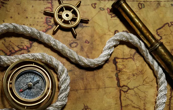
A couple of days later he headed down to the docks as dawn was breaking, carrying his compass, charcoal, rope, staff and a watertight scroll containing a sheet of parchment. He must have cut a comical figure among all the burly sailors, with his lanky frame and copper spectacles - a rare sight even in the university. 'Excuse me,' he called out to a man who was coiling ropes in the bow of a small rowing boat. 'Is that your boat?' The man nodded, eyeing him suspiciously. 'It is, not that it's anything to do with you. What's a small fry like you doing down here anyway? I'd have thought a nose accustomed to the smell of books would find it a deal too fishy.' Tollivant wrinkled his nose involuntarily. 'Well yes, it is rather pungent, he said, 'but I find it quite invigorating, actually. It makes me think of fresh adventures.' 'Whatever the petch invigorwhatsit means,' the man muttered under his breath and turning back to his ropes. He was bored of this strange boy. But Tollivant wouldn't be deterred. 'Excuse me,' he said again, 'but I was wondering if your boat is for hire? With you in it, obviously. I need to go about a mile up the coast to the north. I've got mizas if you'll take me...' The man was more interested now. This boy might be a pipsqueak little child, but the cut of his clothes and the smoothness of his hands did indeed speak of a rich background. 'How much?' the man asked. Tollivant hesitated. He had no idea how much a mile in a boat was worth. '1 gold miza,' he suggested after a pause. 'Or double that if you'll come with me up the valley as well. I'll be spending the day there making a map and I could use some protection.' He could see a harpoon in the man's boat, and although he wasn't sure you could use a harpoon on land, the man looked like he could probably turn a branch lying around into a weapon if need be. The man accepted immediately, leaving Tollivant to worry he'd offered too much money. But the deal was done now. He climbed awkwardly into the boat, managing to keep his bag but not his shoes dry, and they pulled out, the man's strong arms powering the boat quickly through the calm water. After about half a chime the river mouth beyond the ridge was visible in the distance, and another half a chime later Tollivant was hopping out, getting his shoes wet again in the process, as the sailor tugged the boat up onto the sandy river bank and looped a rope around a nearby tree, tying a knot with deft movements that Tollivant couldn't follow.
Last edited by Tollivant Brennson on May 26th, 2017, 2:31 pm, edited 3 times in total.
User avatar
Tollivant Brennson
Player
 
Posts: 26
Words: 31196
Joined roleplay: April 28th, 2017, 5:58 pm
Race: Human
Character sheet
Storyteller secrets

Alar's new farm

Postby Tollivant Brennson on May 9th, 2017, 5:47 pm

Image
While the sailor was tying the boat up and stowing the oars, Tollivant took the opportunity to inspect the area. It was lightly wooded with pine and beech trees, and grassy underfoot. The river was several metres wide at the mouth, its gentle current a hint that its course had been relatively flat for some distance. It had carved several shallow channels into the pebbly beach where it met the sea. Upstream he could see it winding between trees towards the high ground in the distance. He couldn't be certain, but it looked as if the trees thinned out a little further up, hopefully opening out into the fertile valley Alar was looking for.

The night before, he had turned his long rope into a rough but adequate measuring tape. He had folded the rope in two and marked the centre point, then folded both halves over to meet in the middle and marked the quarter points, and then folded one of the quarters over four times to create five foot markers. He had then lined the finished quarter up against each of the other three in turn, and copied the foot markers across, so that in little more than 15 chimes he had 100 feet marked out on his rope. He had also tied loops of string around each end.

He now took this rope out of his pack, and hooked one of the end loops over the arm of his staff, which he had planted firmly into the beach right where the river met the sea. He walked the rope along the river and found a stick to plant into the ground at the hundred foot point. Looping the end of the rope round the stick, he walked back along the rope, measuring the distance between the rope and the river every 10 feet by marking out the distance with a string and then using the rope and his ruler to measure the string. He knew it wasn't perfectly accurate - he would have needed a proper measuring tape and ideally a partner to hold the rope steady to produce something really accurate - but he figured it would do for Alar's purposes. All he really needed was a good idea of the river's overall course, not it's exact position to the nearest inch.

As he walked and measured, Tollivant noted down the distances between the rope and the river in his notebook. He was careful to label each measurement clearly so that he would be able to recreate the scene from his data later on. Once he was back at the river mouth, he took out his compass and sighted along the rope, noting down the orientation - just west of north west - in his notebook as well. He quickly calculated the perpendicular orientation and then walked back along the rope, unhooked it, and carried it to the river mouth. He now laid it out along the angle he had just calculated and measured the distance from the river mouth to the edge of the valley, where the ground started sloping upwards. He had to use several intermediate markers, each 100 foot from the next and carefully sighted with the compass to make sure the overall line was straight.

Once he had done that, he had the beginnings of a right-angled grid marked out, one axis aligned roughly with the river, and the other representing the width of the valley. He performed the same traverse operation as before, measuring the distance between his base line and the shore every 10 feet, to mark out the course of the coastline, and again up the side of the valley to plot the position of where the ground started to slope. There was one large boulder halfway between the river and the valley edge, and he plotted its position by laying a line between it and the original start point, measuring the distance and calculating the angle so he knew where to place it. Other than that, there were no large features in this section. Once he had mapped out the first 100 feet of valley between the slopes and the river, he moved his staff up to the 100 foot mark, and prepared to start the whole thing again for the next 100 feet.

The sailor had been sitting on an old, half-rotten tree stump near the river mouth throughout this entire process, watching Tollivant's endless progression back and forth along the shoreline, hauling the rope and his staff through the trees as he went. Tollivant had decided not to ask for his help because he wanted to be sure that every measurement was as accurate as possible - a careless error on the part of an inexperienced partner could multiply as the map progressed, and end up throwing an entire axis out by several metres further down the line. But after about a bell of watching Tollivant laboriously stretching out his rope, taking his measurements and then having to walk the length of the rope again to retrieve it before he could place a new line, the sailor piped up. 'You know, if you let me carry the rope for you we'd be done with this petchin business a whole lot quicker. At this rate we'll be here 'til next shykin year. If I'd known we'd be moving slower than a limping snail I'd have brought my net, it's got a hole in it I want patched up. Petchin hate sitting around doing shyke all,' he muttered.

Tollivant scratched his head. There was no denying that this was taking longer than he'd anticipated. He'd never mapped out a large area without at least one other cartographer to help him before, and normally they worked in teams. On the other hand, if the sailor didn't lay the rope exactly straight and taut, the measurements would be off, and the map would be ruined. He looked upstream. The high ground at the other end of the valley was at least half a mile away. That meant at least 25 more 100 foot sections to cover. If he didn't speed up, they'd still be here when it got dark. He had no choice; he just had to trust the sailor would understand his instructions and carry them out properly.


Word count: 1643 total
User avatar
Tollivant Brennson
Player
 
Posts: 26
Words: 31196
Joined roleplay: April 28th, 2017, 5:58 pm
Race: Human
Character sheet
Storyteller secrets

Alar's new farm

Postby Tollivant Brennson on May 22nd, 2017, 8:03 pm

Image
The mismatched pair continued working up the valley as the sun rose higher and higher. By noon they were both sweating, but had made good progress. Subsequent sections were all quicker than the first, as they did not need to map the base line of each. Also, the valley narrowed slightly as they got further from the shore, and Tollivant made the decision to only map the southern side of the valley, which opened out a few hundred metres upriver into a wide, flat plain, while the northern side was thickly covered with trees as far as they could see. For now, Alar would have plenty of land on the southern side without needing to chop down an entire forest.

After a quick lunch of the apples and bread Tollivant had brought in his backpack, they finished mapping out the valley floor. There was a stream flowing across the plain from the ridge to the south, and Tollivant plotted its course while noting that the area around the stream was quite boggy and wet, and probably not suitable for farming. He also plotted the positions of several more rocky outcrops and a stand of trees near the river. By the time they had finished, it was mid-afternoon. They started walking back towards the sea, Tollivant carrying the heavy rope coiled around his shoulders and his staff in one hand. One end of the rope kept coming loose and dangling between his feet, where he invariably tripped over if after a few steps. After several such falls, one of which left him with a bleeding nose where he had managed to knock his staff against his face as he tried to steady himself, the sailor took pity on him and heaved the rope effortlessly onto his own shoulders, tying the ends in a knot around his waist to keep them out of the way. Tollivant was suddenly glad he had let the sailor help, after all.

They walked following the edge of the valley, searching the ridge to their right for gaps in the high ground. After a couple of false starts exploring potential gaps that turned out to be dead ends, they found one that looked promising. The ground still sloped upwards, but the gradient was much less steep than the surrounding hills. They climbed steadily for a while, and eventually the ground levelled out. The narrow gap between the hills wound round the higher ground a few times, before starting to descend again, and then opened out as it rounded the last spur. The forest on the other side of the ridge grew thickly up the sides of the hills, and the opening of the path was hidden by the trees on that side, but it was easy to see once you knew it was there. The city was not far away on the other side of the forest, so if Alar could get his cart to the gap, he would have a clear run through to the valley. As they retraced their steps back along the path, Tollivant laid out the rope to measure the length and orientation of each zigzagging section between the spurs. Once they were back in the valley, they headed towards the shore, measuring the distance from the entrance to the pass to the sea in hundred foot intervals as they went.


Back in Zeltiva, Tollivant paid the sailor, adding a few extra gold mizas to the price of the boat to make up for the amount of work the man had ended up doing. Carrying the rope as he had seen the sailor do it with the ends knotted around his waist, he hauled himself up the hill towards the university. The day had left him physically exhausted, his feet had blisters and his legs were aching from the unaccustomed walking, but he still had work to do. Luckily it was work he enjoyed. As he entered the library, he breathed in the beloved smell of musty books. Too much fresh air and exercise always made him long for the comforting aroma of knowledge. He unpacked his notebook, unfolded a piece of parchment, took out his ruler and quill and ink, and began plotting the map. He first worked out a rough scale for the map. He knew that the section of river he had mapped was about eight times longer than the valley was wide, so the shoreline would have to be right in the corner of the map. That would give him space to draw the river running diagonally across the map. He used charcoal and a ruler to draw out the basic grid of the two axes – river and coastline – and then measured the lines he had drawn. Comparing the line on the map with the real life measurements would allow him to calculate the exact scale. The first line on the map could be any length, as long as everything that came after it was in proportion to it.

Once he had the grid in place, he used compass readings he had taken every hundred feet to superimpose a zigzagging line representing the progress of his rope along the valley. He then used the ten-foot interval measurements of distance between the rope and the river to plot out the river’s course in more detail. He did the same along the coastline, and along the valley floor, and marked the point where the pass he and the sailor had found began. Once he had the shape of the valley and the river, it was easy to plot the position of the rocky outcrops and trees that dotted the valley floor. The only thing he had not been able to work out was exactly what direction the southern exit of the pass lay in from the city. To do that, he would have needed to map out the coastline all the way from the valley to the city, and that would be a whole other day’s work. For now, he completed the map by drawing in little trees in areas that his notebook told him were wooded, and sprouts of grass in areas that had felt boggier underfoot, along most of the river. He always enjoyed this part; it turned the map from a representation of measurements and numbers into the representation of a real place, and also of the cartographer who drew it. He could recognise which of his fellow students had drawn any given map simply by looking at the way the trees were drawn. It was like handwriting and each cartographer had their own style. His was still developing, and his drawing skills were not yet good enough to do more than simple, blocky trees, but master cartographers could conjure up entire landscapes on their maps, breathing life into flat surfaces.

When he was satisfied, he rolled the parchment up and tied it tightly with string, and then forced himself once more back onto his tired feet to deliver the map to Alar. Job done, the two men headed to their usual haunt for several mugs of kelp beer.


Total word count: 2825
User avatar
Tollivant Brennson
Player
 
Posts: 26
Words: 31196
Joined roleplay: April 28th, 2017, 5:58 pm
Race: Human
Character sheet
Storyteller secrets

Alar's new farm

Postby Karyk on June 7th, 2017, 10:43 pm

Image
 
Characters Name
Your Grade is being withheld due to your Character Sheet lacking a Green Checkmark on it. Please PM Prophet asking him to review it. When approved and checkmark granted, send me a PM and I'll release your grade.


Notes and Comments
CS Checkmarked: X
CS Reviewed by Me: ✓
Previous Season Expenses Paid (Spring 517): ✓
Follow your heart, and the plot will follow.
User avatar
Karyk
Player
 
Posts: 326
Words: 273057
Joined roleplay: April 4th, 2017, 4:34 pm
Location: Zeltiva
Race: Human
Character sheet
Storyteller secrets
Plotnotes


Who is online

Users browsing this forum: No registered users and 0 guests